Currency
![]() Buy Now - Pay Later Get 4 interest-free payments Use PayPal at Checkout Learn More...
Buy Now - Pay Later Get 4 interest-free payments Use PayPal at Checkout Learn More...
![]() Buy Now - Pay Later Get 4 interest-free payments Use PayPal at Checkout Learn More...
Buy Now - Pay Later Get 4 interest-free payments Use PayPal at Checkout Learn More...
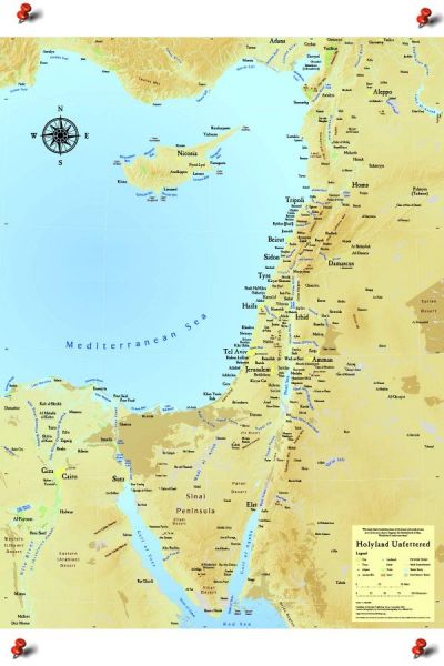
Large Biblical & Modern Day Map of Israel
A highly detailed cartographer's map of modern and ancient Israel,produced in full-color. Featuring biblical and modern sites; archeological sites; topographical features; including mountains wadis & arid areas. It has extensive markings of cities, towns, and villages, and includes the entire region with amazing clarity. This map is "unfettered" by modern day political borders. Printed in Israel.
Suitable for framing Size 36" high x 24" wide.
Map is fully LAMINATED - Tear Proof!
This Map of Israel can be ordered as is - or with Wall Frame 27" x 40" (Shipped Separately).
Select below with or without frame.
About - Large Biblical & Modern Day Map of Israel
A highly detailed cartographer's map of modern and ancient Israel,produced in full-color.
Featuring biblical and modern sites; archeological sites; topographical features; including mountains wadis & arid areas.
It has extensive markings of cities, towns, and villages, and includes the entire region with amazing clarity. This map is "unfettered"
by modern day political borders. Suitable for framing Size 36" high x 24" wide.
This map is a geographically accurate map of Israel and its surrounding vicinity and, at the same time, is a stunning portrait of the Holyland. It is both exceptionally informative and aesthetically pleasing.
The map is drawn to a 1: 1,300,000 scale and was custom designed using the most up to date version of the National Imagery and Mapping Agency’s Digital Chart of the World. The map covers the area from the Nile River in the West to the Euphrates River in the East and from the tip of the Sinai Peninsula in the South to the coast of Turkey in the North. It shows the area’s topography (using relief shading), major rivers, water bodies and mountains, historic and Biblical sites, international airports and major population centers.
This product is an excellent medium to bring the beauty of the Holyland into your home, school or House of Worship. It also makes a wonderful gift for your friends, family members and business associates.
The standard edition is 24” by 32” and is printed on handsome, sturdy paper with a matte finish. It is shipped rolled, not folded, and is suitable for framing.
The laminated edition is 24” by 36” with a two inch white border on top and on bottom for tacking purposes. It is laminated for increased durability and is suitable for a schoolroom or office.